
The area of Pembroke which is south of the town walls is called The Commons and today provides a large car parking area. It also contains a community centre, recently refurbished, which was at one time a foundry, and a youth club housed in what was a tannery. It has a tourist information centre and library and a nearby Chinese restaurant where once a slaughterhouse stood.
Numerous other buildings have disappeared over time, while others have been converted or rebuilt to provide the library and tourist centre, a tile supply store, Creative Photography Studios and a comprehensive hardware, DIY, locksmith and PVC double glazing fabrication outlet.
In addition, there is a large area of grass and trees, a football pitch and a children's play area. Beside the much-widened road runs a stream in a channel which runs out under the Monkton Bridge into the Pembroke River.
On the south side are the houses of Orange Gardens, described as Pembroke's first 'suburbs', built between 1870 and 1900 on land owned by Orielton Estate, with the original name 'Orange Town' derived, many say, from the large house 'Orange Hall' shown on early maps as on the south-western edge of Monkton.
The original 'grid iron' layout has over the last hundred years been surrounded on the south by numerous other housing developments, but still retains much of its original compactness and community spirit.
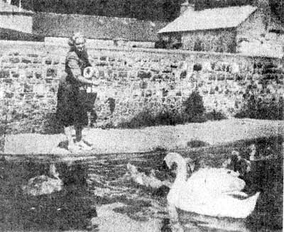
The photographs with this article were provided by John Russell, a well-known figure in the area and show from the Orange Garden side the lake (or relief pond) that once occupied a part of the common now occupied by the football pitch and the children's play area. Beyond the lake, with its two islands, can be seen the extensive buildings situated on both sides of the road which, of course, was much narrower than it is today. Amongst these are the aforementioned, with the addition of the remains of the town's gasworks, a rabbit factory, a council yard, and a series of allotments.
The small photograph shows a local lady feeding swans and ducks which lived on the lake, along with coots and moorhens. Early maps show the common as a tidal area of the Pembroke River, with the water at spring tides reaching up to near the New Way Bridge and the area beyond occupied by geese which wandered freely, tended occasionally by goose girls, until their time arrived to go to market when they were made to walk through warm asphalt and gravel to prepare their feet for the journey ahead.
The formation of the lake was to prevent flooding in the area by both tidal water and the stream rising at a point near West Hill, north of Lamphey, which flows through Alleston Farm, skirting Primose Valley, Merlin's Cross, and the Lower Lamphey Road and at one time working Slothy Mill and finally passing under the bridge at the bottom of Well Hill and on to the common.
It's creation provided certain groups in the town with a point of interest. John Russell speaks enthusiastically of skating visits when the lake froze over, as it did regularly during the 1920s and '30s, being of course quite a shallow stretch.
Two notable figures John remembers, as being prominent in lake activities, one being Mr. Reginald Evans, manager of Barclays Bank in the Main Street, who was a stylish skater on the lake and indeed the Mill Pond, so much so that he had proper skating footwear, whereas John and his friends had simple shaped blocks of wood with a blade embedded in the bottom which they then strapped on to their normal boots or shoes. The other was Mr. A. G. O. Mathias, manager of the Penny Savings Bank, also in the Main Street, who not only regularly fed and attended the swans and ducks, but also kept owls in the upper storey of his bank.
The lake was finally drained by the council in the late 50s and filled in and the water channelled between two concrete walls. In the last few years, this stream channel has been refurbished and landscaped, but recently problems have seemingly arisen because of the vegetation planted along the banks.
George Lewis
Comments
This article has no comments yet. Be the first to leave a comment.